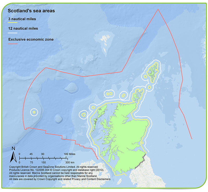
Scotland has around 18,000 km of coastline (when measured at 1:10,000 scale). The area from the coast to our EEZ (Exclusive Economic Zone) limits (462,263km2) is around six times the size of the land area of Scotland.
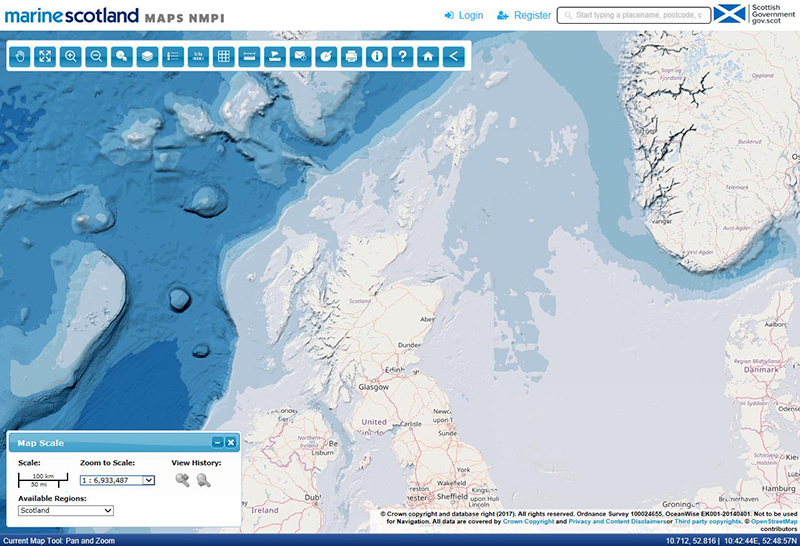
Scotland's Marine Assessment 2020 (SMA2020) portal reports on the vision for Scotland's seas. You can find updated data sets used as part of the assessment on Marine Scotland Maps (NMPI).
Key messages
Most of our seas, coasts and estuaries are in good or excellent condition that is clean and safe. There are localised areas of concern, but pollution problems caused in the past have largely been addressed. Our seas are healthy and biologically diverse, supporting around 6,500 species of plants and animals and nationally and internationally important populations of certain species. Our seas also contribute to the economy, supporting a wide range of human activities, e.g. offshore renewable energy and leisure and recreation such as diving, yachting and some wildlife watching.
The two widespread significant pressures on offshore waters are:
Many competing human activities have resulted in the first National Marine Plan being published in 2015 following the passing of the Marine (Scotland) Act 2010.
Growth in industries such as aquaculture and renewable energy may increase pressure on coastal waters.
Almost all (98 %) of Scotland's coastal and transitional waters are in good or better condition as reported in Scotland's River Basin Management Plan. RBMP3 (sepa.org.uk)
Scotland has approximately 48,000 km2 of coastal waters (internal waters and sea within the three mile limit), which vary from sheltered sea lochs to exposed shoreline.
Scotland’s seas extend from the coastline to the Exclusive Economic Zone (EEZ) limit, generally about 200 nautical miles, covering a sea area of 462,263 square kilometres (km2). Beyond the EEZ is the seabed forming the continental shelf.
Scotland’s seas range from shallow shelf seas (less than 200 m deep) to deep oceans (more than 2000 m deep). The shelf seas contain features like banks and deep channels, whereas the deep oceans have complex, varying depths broken up by steep ridges, seamounts (mountains under the sea) and banks.
Data
View the quality of Scotland’s coastal waters
View the full data analysis application for further information about the water body classification
View the quality of Scotland’s bathing waters
View the full data analysis application for further information about bathing waters
Marine Scotland gathers and uses a wide range of data and information as part of its work.
Marine Scotland INFORMATION (MSI) – Marine Scotland’s new integrated web portal that provides access to descriptions and information about the Scottish marine environment while providing links to datasets and map resources that are made available by Marine Scotland and partners. Content is grouped into 3 types: information, maps and data.
Marine Scotland MAPS (NMPI) is an online, interactive GIS-based tool allowing you to view different types of information (as layers) at a scale of your choice and undertake a number of functions with the map layers including creating maps for printing. It was developed to provide a digital version of Scotland’s Marine Atlas and is structured around the themes ‘clean and safe’, ‘healthy and biologically diverse’ and ‘productive’, supported by layers on ‘physical characteristics’, ‘climate change’ and ‘administrative’, and including National Marine Plan map archives and regional planning data.
Where possible links are provided to the related parts of Scotland’s Marine Atlas, updated graphs and data as well as links to data sources to facilitate data download. NMPi has expanded to support both marine planning and a number of other organisations by making their spatial data visible through Web Map Services (WMS), and providing links through MSI to more detailed information on the layers. The portal now hosts more than 1000 spatial data layers, a significant proportion of which requires maintenance with updates at varying intervals.
Marine Scotland DATA is a dedicated portal that allows you to search Marine Scotland’s published datasets and reports. Citation information for these datasets is provided using Digital Object Identifiers (DOIs). The portal is being developed, with new content added regularly which:
- Provides a single point of access to Marine Scotland’s published data, and allows everyone to explore, download, share and cite those data.
- Provides a user interface for searching datasets as well as machine readable services to locate and retrieve data.
- Describes each data set with standardised metadata, and downloadable resources, described in detail in terms of units, use of vocabularies, etc.
- Groups data sets into broader topics to help exploration, but all content is also searchable across the portal.
- Publishes datasets consisting of one or more downloadable resources.
- Makes available downloadable data, released under the UK Open Government Licence, where possible.
- Uses persistent identifiers to allow accurate citation and location of datasets, even in the event of web sites changing or moving addresses.
Scotland's Marine Assessment 2020 (SMA2020) is a purpose built content management system to deliver the content for SMA2020. It organises content into a thematic structure that holds a variety of information:
- Introductions and methodology sections providing summaries of the way the assessment was conducted, including outcomes from peer review, and acknowledgements.
- Technical and economic assessments, organising content into different sections with expandable background information and links to evidence in the form of literature, data, and maps.
- Use cases that provide specific examples and context for the given theme
- Ecosystem service summaries with overviews of cultural, regulation, supporting services and benefits for people
- Assessments of pressures from activities, organised by Scottish Marine regions.
- Regional assessments, summarising findings for each Scottish Marine Region.
The overall page structure of the SMA platform includes 183 components:
-
- 66 vision assessments (technical assessments)
- 36 use cases
- 19 climate change assessments
- 12 ecosystem services assessments
- 21 pressures regional assessments
- 21 summary regional assessments
- 4 introductory chapters
- 4 managing the human activities chapters
In addition to the visual components like these pages, there are numerous constituent parts. Most of the individual sections within these pages include image files of graphs, examples, and the marine environment – in total 2,550 images.
Pages are linked to evidence in the form of literature sources and datasets. There are 1,137 individual literature and data resources that were also added to the system.
What are we doing?
The Marine (Scotland) Act 2010 included measures for:
- Marine planning - a statutory marine planning system to sustainably manage the increasing, and often conflicting, demands on our seas. The first National Marine Plan, which was published in March 2015, provides the guiding framework for sustainable management of marine activities and resources, setting out a series of policies to inform decision-making. Reviews of the National Marine Plan were conducted in 2018 and 2021. In the Programme for Government 2022 - 2023, Scottish Ministers committed to start the process of developing a new National Marine Plan for Scotland, to address the global climate and nature crises, by carefully managing increased competition for space and resources in the marine environment.
- Marine licensing - a simpler licensing system, minimising the number of licences required for development in the marine environment to cut bureaucracy and encourage economic investment.
- Marine conservation - improved marine nature and historic conservation with new powers to protect and manage areas of importance for marine wildlife, habitats and historic monuments.
- Seal conservation - much improved protection for seals and a new comprehensive licence system to ensure appropriate management when necessary.
- Enforcement - a range of enhanced powers of marine conservation and licensing.
Marine Scotland also has responsibilities for fisheries management, aquaculture and marine science through its laboratories.
Regional planning
The Marine (Scotland) Act in 2010 also introduced regional marine planning as an entirely new element of marine management, along with other elements to improve marine management. Scottish Marine Regions Order (2015) established the boundaries for the creation of 11 Scottish Marine Regions around Scotland.
Currently three (out of 11) Marine Planning Partnerships (MPPs) have been established in Shetland (March 2016), Clyde (March 2017) and Orkney (November 2020). There are no statutory RMPs in existence at this time.
Policy and legislation
There is legislation at various levels that contributes to planning Scotland’s seas.
UK
Scotland
More details are available from The Scottish Government website and the Marine Scotland Marine Plan Topic Sheet.
This page was updated on 14 Feb 2023
Adobe Acrobat Reader is the free, trusted leader for reliably viewing, annotating and signing PDFs.
Download Adobe Acrobat Reader


